
Colonial Settlement and the History of Mahuru Springs
|
The property of Mahuru Springs, it appears, was originally part of the Woodside Estate, “an area bounded by the Mangaonua Stream and the Hamilton-Matangi Road and both sides of Woodside Road” (Heritage Waikato) and may have been either part of the parcel purchased by Billy Runiciman or Tom Bryant. Latterly, the property of Mahuru Springs was part of a parcel owned by the Butcher family, which included the whole of what has become Butcher Road, and has since been subdivided. The house itself, known as the “Butcher Homestead” was built in the 1940’s and is believed to have been situated on the Woodside Road end of Butcher Road, the later of which was then apparently a farm track. During the 1970’s the homestead was relocated to the far end of Butcher Road where it remains to this day, but in a transformed state having undergone changes across the years, including extensive renovations in 2011.
A look at the history of the land now referred to as Mahuru Springs, shows a harrowed line of guardianship and ownership as Europeans colonised the area and the Waikato Wars forced the hands of local iwi to stop fighting and relinquish their lands. With land confiscation by Pākeha in full swing, primarily in the Waikato for the purposes of housing Militia, an area of land was left, being labelled as “Tamahere Native Land”. According to the map, Mahuru Springs fall within this area. Timeline of European Settlement
1840 Organised settlement by Europeans began, with strong opposition from Māori with regards to the sale of land (Heritage Waikato). |
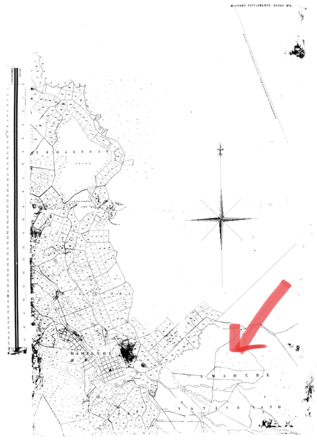
Plan of the Military settlements in the Upper Waikato District, c.1865. The northern boundary of the map is the Komakorau Creek. Most of these 50-acre parcels were allotted to men of the 4th Waikato Regiment. The large parcel allocated as ‘Tamahere Native Land’ is shown at lower right.
|
1863, June Following an uneasy twenty year long period between and Pākeha, the Waikato Wars ensued; the final straw having been the push by the Pākeha government to force Māori allegiance to Queen Victoria. “The Waikato wars are well documented elsewhere, in the area we are concerned with there was little fighting. The Maoris had retreated to their well-fortified pa's, and although hostile, did not worry the white settlers in Cambridge and elsewhere. At about this time the Government was advertising in newspapers in Australia for military settlers. The recruits would serve as militiamen for three years, and at the end of this time would be granted one acre in the town, and 50 acres of farm land” (Heritage Waikato).
According to Ngā kōrero ipurangi o Aotearoa/NZ History, “The government decided to pay for the war by confiscating land, including the vast area it had occupied in Waikato. Confiscation of the land of Māori ‘engaged in rebellion’ was given a cloak of legitimacy by the New Zealand Settlements Act 1863. Grey had signalled the likelihood of such consequences in the ultimatum he issued as his troops invaded Waikato in July 1863: if they took up arms against the Crown, Māori would forfeit the ‘right to the possession of their lands guaranteed to them by the Treaty of Waitangi’. The land confiscated included most of the lower Waikato district, including some areas occupied by neutral tribes and a third of the land of Ngāti Hauā. Māori called this confiscation the Raupatu. Ngāti Maniapoto largely avoided confiscation. Their land was difficult to access and not considered valuable. This seemed to confirm suspicions that the real purpose of the war had been to acquire fertile land nearer Auckland for settlement”.
Included in the land confiscations of the 1860s was “The eastern part of the district, south of the Hapuakohe hills ... Several blocks, generally bordering streams and rivers, were subsequently surveyed into 50- acre parcels as grants to militiamen of the Fourth Waikato Regiment: largely around Komakorau, Horsham Downs and Tamahere. Areas such as Hillcrest, Ruakura, Claudelands, Queenwood, Flagstaff, and Rototuna which were once in Waikato County or District, were also part of the same survey and settlement process. Militiamen-settlers found access to their rural allotments was difficult, if not impossible, because of the steep gullies and lack of roads and bridges. Many allotments were swampy and were exchanged for other parcels or were sold or abandoned within the first few years of ownership (from 1864)” (Waikato District Plan Review - Built Heritage Assessment (Historic Overview - Eastern Sector).
1865 “Thorne Buckland, impatient at the Governments slowness in opening tracts of land for settlement paid Wiremu Tamehana a visit to persuade the chief to lease land to the settlers. Buckland was shocked at the state of Tamehana's people, the crops had failed, food and clothing was short and there was much illness. With the assistance of Mr George Graham, Buckland arranged a meeting between Tamehana and General Carey at Tamahere where the two men made peace, Tamehana pledging that his men would fight no more in the Waikato. The military settlers were keen to claim their land, but were disgruntled to find that at the first sitting of the Native Land Court fifteen thousand acres at Tamahere and ten thousand acres at Tauwhare had been returned to the 'Friendlies' of the Ngati-Haua tribe. This fifteen thousand acres at Tamahere includes the land which is now Matangi” (Heritage Waikato). It is noted by Ngā kōrero ipurangi o Aotearoa/NZ History, that “allies such as Ngāti Hauā had resumed selling land even before Wiremu Tamihana’s death in 1866”, allowing the Native Land Court to issue titles to their land. This is not surprising given the desperately poor living conditions within the Rohe Pōtae (the Māori King's territory).
1869 A record of land allotment (which later changed hands as recorded under Certificate of Title (Vol 39, Folio 223)) included the following. “Allotment 29 to Penetito, Allotment 29 to Heterata Wheora, Allotment 30 to Mere Wirihana, Allotment 31 to Hori Wirihana, Allotment 32 to Hori Wirihana, Allotment 33 to Whakarake, Allotment 34 and 41 to Whakamoka, Allotment 35 to Mete Ruaone, Allotment 36 to Hori Kuapuka, Allotment 37 to Rangi, Allotment 38 to Miriama Hapeta, Allotment 39 to Ratira te Haka and Allotment 40 to Penetito” (Heritage Waikato).
1881, 5th of May A Certificate of Title (Vol. 39, Folio 177) was issued to Browne Wood for “nine acres, two roods 35 perches, being Section 138, Parish of Tamahere” (Heritage Waikato) which was said to be a narrow strip which ran across the aforementioned land.
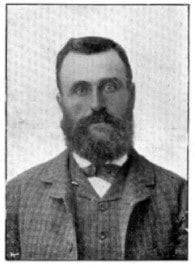
Mr. John James Graham, manager of the Woodland Estate which was owned by the N.Z. Loan and Mercantile Agency Co. from 1885-1906
|
1885, 17th of June The Certificate of Title (Vol. 39, Folio 223) for 1648 acres 2 roods 35 perches was issued to Wood. “ It is surmised that Wood bought the first piece of land of nine acres odd when it became available and the remainder from the Maori owners as he was able to complete the purchase, a title for the whole of the latter purchases being issued to him in 1885” (Heritage Waikato). It is thought that the homestead was erected this same year. It is documented that, “Wood mortgaged his property (except the original nine acres which was presumably accidentally missed) to the New Zealand Loan and Mercentile Agency Co Limited. In1890 the mortgagee offered the property by public auction at the Hamilton Saleyards ... The advertisement of the sale described the property as follows: "The property is fenced and sub-divided and about 1,100 acres are in grass or under cultivation. There is a seven roomed house, two cottages, large stable and other necessary buildings. The farm is situated about two miles from Hamilton East and a large proportion of the farm is of first class quality". The period was, of course, one of financial depression. The N.Z. Loan and Mercantile Agency Co., held the property with a Manager, John James Graham until 1899, at which time it carried between 2,000 and 3,000 sheep”
|
1886 An excerpt from the Cyclopedia of New Zealand [Auckland Provincial District] states that Woodside Estate is “pastoral property owned by the New Zealand Loan and Mercantile Agency Company, in the Newstead district, county of Waikato. It carries between 2000 and 3000 sheep, and is managed by Mr. J. J. Graham”. John James Graham was originally from the County of Tyrone in Ireland, having been born in 1850 and laterly arriving in Aotearoa New Zealand on the ship Andrew Jackson. He was appointed as the manager of the Woodside Estate in 1886. It is noted that he always took “considerable interest in local matters of every kind, and [was] an energetic member of various local bodies”. He married “a daughter of Mr. Finlayson, an old Waipu settler, and [had] three daughters”.
1890 Slightly different to the previous entry, the Waikato District Council District Plan Review – Built Heritage Assessment (Historic Overview - Eastern Sector) identifies this as the year that “the 1680-hectare farm was taken over by the NZLMA”.
1906 The property changed hands, having been bought by John Knight. It was in this years with the Post Office having been opened, that the name Matangi came into common use for the local area (Heritage Waikato).
1913 The Goodwin brothers from Pigeon Bay “transferred to the Woodside Land Settlement Association” (Heritage Waikato), subdividing the property and selling it to a range of buyers. It is said that, “Demand for the land was such that a ballot was held and the original purchasers are as follows: Mr Stretton 50 acres; Mr Reynolds 100 acres; John Bettley 300 acres; Mr Preece 100 acres; Rolley Hinton 100 acres; George Burnett 100 acres. These properties all fronted onto Matangi Road. Up the left-hand side of Woodside Road Billy Runciman drew 140 acres; and Tom Bryant drew 360 acres. Up the right-hand side of the road Harry Robinson drew 70 acres and Frank Goodwin drew 100 acres. Harry Taylor drew land which fronted Matangi Road east of Woodside Road. The 200 acres with the main homestead was drawn by Mr Job Hinton at the end of what is now Websters Road”. Given the descriptions, it would seem that Mahuru Springs was either the land previously owned by either Billy Runciman or Tom Bryant. A variation of this recount is recorded in the Waikato District Council District Plan Review – Built Heritage Assessment (Historic Overview - Eastern Sector), in which it is said that, “In 1913 the Woodside Land Settlement Association, a conglomerate of twelve local farmers and businessmen, purchased the property and subsequently divided it amongst its members” (p. 136).
More recent history pertaining to the land presently referred to as Mahuru Springs, remains unknown. Again, should you have further information as it pertains to the above, or additional or differing perspectives to share, please drop me a line.
